
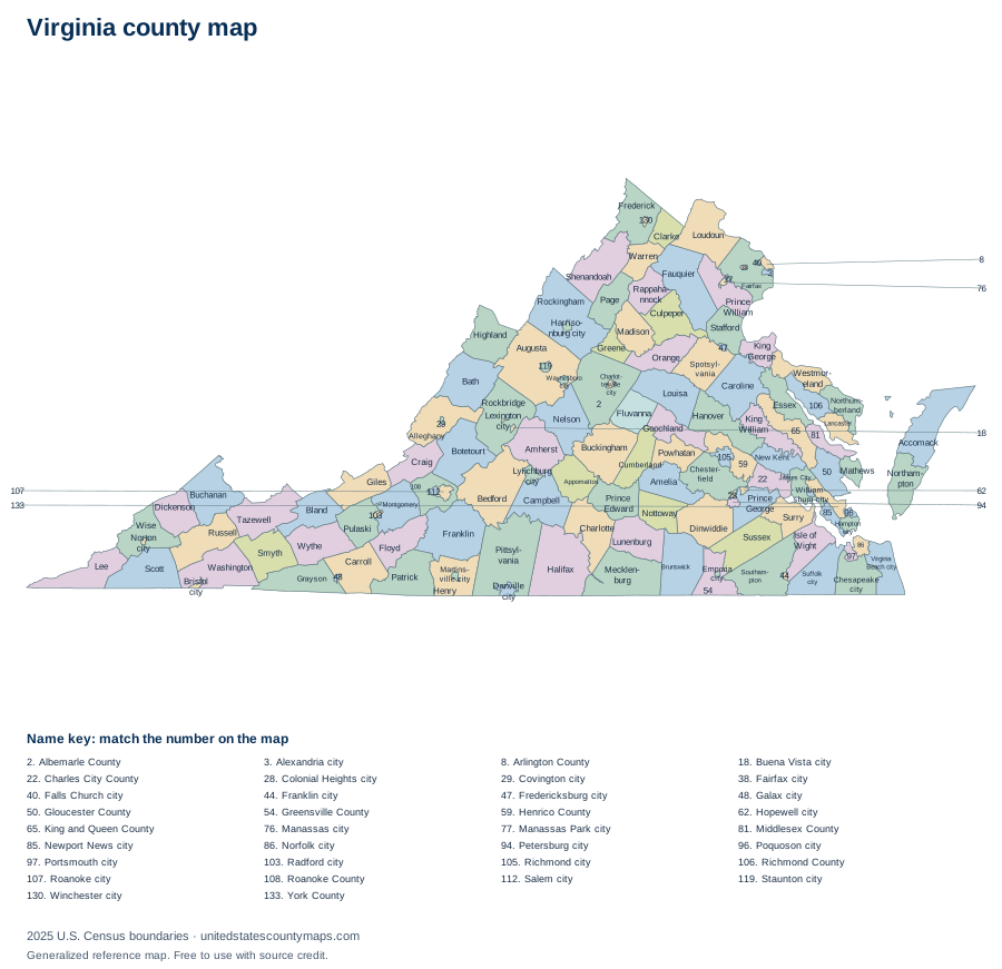
Virginia county geography overview
Virginia has 133 counties and independent cities, which places it 3rd among the 50 state and District of Columbia maps in this atlas when ordered by number of county-level units. Their combined 39,480.7 square miles of land place the state 37th by mapped land area.
The average county-level area is 297 square miles, while the median is 310 square miles. The median is often the better description of a typical unit because one or two very large areas can pull the average upward. The five largest units together account for about 11% of the state’s mapped land area.
Largest and smallest Virginia counties and independent cities
Pittsylvania County is the largest county-level unit by land area at 969 square miles. It represents about 2% of all mapped land in Virginia. At the other end of the range, Falls Church city has 2 square miles of land.
Largest by land area
- Pittsylvania County969 sq mi
- Augusta County967.1 sq mi
- Rockingham County849.8 sq mi
- Halifax County817.7 sq mi
- Bedford County760.1 sq mi
Smallest by land area
- Falls Church city2 sq mi
- Lexington city2.5 sq mi
- Manassas Park city3 sq mi
- Covington city5.5 sq mi
- Fairfax city6.2 sq mi
Rankings use land area rather than total area. This avoids making coastal or lake counties appear larger solely because their boundaries include extensive water.
Alphabetical list of Virginia counties and independent cities
The table is alphabetical, so it works as a name and FIPS-code reference rather than an area ranking. Every identifier begins with the Virginia state FIPS prefix 51. Land and water figures are rounded to one decimal place.
133 county-level areas
Download county data / numbered map key (CSV)| No. | Name | FIPS code | Land area | Water area |
|---|---|---|---|---|
| 1 | Accomack County | 51001 | 449.3 sq mi | 860.7 sq mi |
| 2 | Albemarle County | 51003 | 720.5 sq mi | 5.5 sq mi |
| 3 | Alexandria city | 51510 | 14.9 sq mi | 0.4 sq mi |
| 4 | Alleghany County | 51005 | 446.6 sq mi | 3.2 sq mi |
| 5 | Amelia County | 51007 | 355.4 sq mi | 3.2 sq mi |
| 6 | Amherst County | 51009 | 474 sq mi | 5 sq mi |
| 7 | Appomattox County | 51011 | 334.2 sq mi | 1.2 sq mi |
| 8 | Arlington County | 51013 | 26 sq mi | 0.1 sq mi |
| 9 | Augusta County | 51015 | 967.1 sq mi | 3.7 sq mi |
| 10 | Bath County | 51017 | 529.2 sq mi | 5.4 sq mi |
| 11 | Bedford County | 51019 | 760.1 sq mi | 16.2 sq mi |
| 12 | Bland County | 51021 | 357.6 sq mi | 1 sq mi |
| 13 | Botetourt County | 51023 | 541.3 sq mi | 4.7 sq mi |
| 14 | Bristol city | 51520 | 12.9 sq mi | 0.1 sq mi |
| 15 | Brunswick County | 51025 | 566.4 sq mi | 3.2 sq mi |
| 16 | Buchanan County | 51027 | 502.9 sq mi | 1.1 sq mi |
| 17 | Buckingham County | 51029 | 579.6 sq mi | 3.8 sq mi |
| 18 | Buena Vista city | 51530 | 6.4 sq mi | 0.1 sq mi |
| 19 | Campbell County | 51031 | 503.3 sq mi | 3.4 sq mi |
| 20 | Caroline County | 51033 | 527.4 sq mi | 9.6 sq mi |
| 21 | Carroll County | 51035 | 474.7 sq mi | 2.9 sq mi |
| 22 | Charles City County | 51036 | 182.9 sq mi | 21.3 sq mi |
| 23 | Charlotte County | 51037 | 475.3 sq mi | 2.2 sq mi |
| 24 | Charlottesville city | 51540 | 10.2 sq mi | 0 sq mi |
| 25 | Chesapeake city | 51550 | 338.5 sq mi | 12.5 sq mi |
| 26 | Chesterfield County | 51041 | 423.5 sq mi | 13.5 sq mi |
| 27 | Clarke County | 51043 | 176 sq mi | 2.2 sq mi |
| 28 | Colonial Heights city | 51570 | 7.5 sq mi | 0.3 sq mi |
| 29 | Covington city | 51580 | 5.5 sq mi | 0.2 sq mi |
| 30 | Craig County | 51045 | 328.1 sq mi | 1.1 sq mi |
| 31 | Culpeper County | 51047 | 379.2 sq mi | 3.5 sq mi |
| 32 | Cumberland County | 51049 | 297.5 sq mi | 2.3 sq mi |
| 33 | Danville city | 51590 | 42.8 sq mi | 0.9 sq mi |
| 34 | Dickenson County | 51051 | 330.4 sq mi | 3.1 sq mi |
| 35 | Dinwiddie County | 51053 | 503.8 sq mi | 3.5 sq mi |
| 36 | Emporia city | 51595 | 6.6 sq mi | 0 sq mi |
| 37 | Essex County | 51057 | 257.3 sq mi | 28.9 sq mi |
| 38 | Fairfax city | 51600 | 6.2 sq mi | 0 sq mi |
| 39 | Fairfax County | 51059 | 391 sq mi | 15.4 sq mi |
| 40 | Falls Church city | 51610 | 2 sq mi | 0 sq mi |
| 41 | Fauquier County | 51061 | 648 sq mi | 3.7 sq mi |
| 42 | Floyd County | 51063 | 380.9 sq mi | 0.8 sq mi |
| 43 | Fluvanna County | 51065 | 287.1 sq mi | 4.1 sq mi |
| 44 | Franklin city | 51620 | 8.3 sq mi | 0.1 sq mi |
| 45 | Franklin County | 51067 | 690.6 sq mi | 21 sq mi |
| 46 | Frederick County | 51069 | 413.1 sq mi | 2.3 sq mi |
| 47 | Fredericksburg city | 51630 | 10.5 sq mi | 0.1 sq mi |
| 48 | Galax city | 51640 | 8.2 sq mi | 0 sq mi |
| 49 | Giles County | 51071 | 357.2 sq mi | 4.3 sq mi |
| 50 | Gloucester County | 51073 | 217.8 sq mi | 70.2 sq mi |
| 51 | Goochland County | 51075 | 282 sq mi | 8.5 sq mi |
| 52 | Grayson County | 51077 | 441.8 sq mi | 3.8 sq mi |
| 53 | Greene County | 51079 | 155.9 sq mi | 0.6 sq mi |
| 54 | Greensville County | 51081 | 295.4 sq mi | 1.6 sq mi |
| 55 | Halifax County | 51083 | 817.7 sq mi | 11.8 sq mi |
| 56 | Hampton city | 51650 | 51.5 sq mi | 84.8 sq mi |
| 57 | Hanover County | 51085 | 467.6 sq mi | 4.9 sq mi |
| 58 | Harrisonburg city | 51660 | 17.3 sq mi | 0.1 sq mi |
| 59 | Henrico County | 51087 | 233.7 sq mi | 11.1 sq mi |
| 60 | Henry County | 51089 | 382.4 sq mi | 2 sq mi |
| 61 | Highland County | 51091 | 415.2 sq mi | 0.7 sq mi |
| 62 | Hopewell city | 51670 | 10.4 sq mi | 0.5 sq mi |
| 63 | Isle of Wight County | 51093 | 315.7 sq mi | 47.1 sq mi |
| 64 | James City County | 51095 | 142.3 sq mi | 36.8 sq mi |
| 65 | King and Queen County | 51097 | 315.1 sq mi | 11.2 sq mi |
| 66 | King George County | 51099 | 179.6 sq mi | 8.1 sq mi |
| 67 | King William County | 51101 | 273.9 sq mi | 12 sq mi |
| 68 | Lancaster County | 51103 | 133.3 sq mi | 98.1 sq mi |
| 69 | Lee County | 51105 | 435.4 sq mi | 1.9 sq mi |
| 70 | Lexington city | 51678 | 2.5 sq mi | 0 sq mi |
| 71 | Loudoun County | 51107 | 515.7 sq mi | 5.6 sq mi |
| 72 | Louisa County | 51109 | 495.1 sq mi | 14.6 sq mi |
| 73 | Lunenburg County | 51111 | 431.7 sq mi | 0.7 sq mi |
| 74 | Lynchburg city | 51680 | 48.9 sq mi | 0.6 sq mi |
| 75 | Madison County | 51113 | 320.6 sq mi | 1.2 sq mi |
| 76 | Manassas city | 51683 | 9.8 sq mi | 0.1 sq mi |
| 77 | Manassas Park city | 51685 | 3 sq mi | 0 sq mi |
| 78 | Martinsville city | 51690 | 11 sq mi | 0.1 sq mi |
| 79 | Mathews County | 51115 | 85.9 sq mi | 166.1 sq mi |
| 80 | Mecklenburg County | 51117 | 625.3 sq mi | 53.9 sq mi |
| 81 | Middlesex County | 51119 | 130.3 sq mi | 80.4 sq mi |
| 82 | Montgomery County | 51121 | 386.8 sq mi | 2.4 sq mi |
| 83 | Nelson County | 51125 | 470.7 sq mi | 3.5 sq mi |
| 84 | New Kent County | 51127 | 210 sq mi | 13.7 sq mi |
| 85 | Newport News city | 51700 | 69 sq mi | 50.6 sq mi |
| 86 | Norfolk city | 51710 | 53.3 sq mi | 43.1 sq mi |
| 87 | Northampton County | 51131 | 211.7 sq mi | 583.5 sq mi |
| 88 | Northumberland County | 51133 | 191.4 sq mi | 94.2 sq mi |
| 89 | Norton city | 51720 | 7.5 sq mi | 0 sq mi |
| 90 | Nottoway County | 51135 | 314.4 sq mi | 1.7 sq mi |
| 91 | Orange County | 51137 | 340.5 sq mi | 2.7 sq mi |
| 92 | Page County | 51139 | 310 sq mi | 3.2 sq mi |
| 93 | Patrick County | 51141 | 483 sq mi | 2.8 sq mi |
| 94 | Petersburg city | 51730 | 22.7 sq mi | 0.2 sq mi |
| 95 | Pittsylvania County | 51143 | 969 sq mi | 9.2 sq mi |
| 96 | Poquoson city | 51735 | 15.4 sq mi | 63.1 sq mi |
| 97 | Portsmouth city | 51740 | 33.3 sq mi | 13.4 sq mi |
| 98 | Powhatan County | 51145 | 260.2 sq mi | 2.1 sq mi |
| 99 | Prince Edward County | 51147 | 349.9 sq mi | 3.9 sq mi |
| 100 | Prince George County | 51149 | 265.3 sq mi | 16.5 sq mi |
| 101 | Prince William County | 51153 | 335.3 sq mi | 11.9 sq mi |
| 102 | Pulaski County | 51155 | 319.8 sq mi | 9.6 sq mi |
| 103 | Radford city | 51750 | 9.7 sq mi | 0.3 sq mi |
| 104 | Rappahannock County | 51157 | 266.4 sq mi | 0.8 sq mi |
| 105 | Richmond city | 51760 | 59.9 sq mi | 2.6 sq mi |
| 106 | Richmond County | 51159 | 191.5 sq mi | 24.9 sq mi |
| 107 | Roanoke city | 51770 | 42.5 sq mi | 0.3 sq mi |
| 108 | Roanoke County | 51161 | 250.5 sq mi | 0.7 sq mi |
| 109 | Rockbridge County | 51163 | 596.5 sq mi | 3.4 sq mi |
| 110 | Rockingham County | 51165 | 849.8 sq mi | 4.1 sq mi |
| 111 | Russell County | 51167 | 473.5 sq mi | 2.9 sq mi |
| 112 | Salem city | 51775 | 14.5 sq mi | 0.1 sq mi |
| 113 | Scott County | 51169 | 535.8 sq mi | 3.1 sq mi |
| 114 | Shenandoah County | 51171 | 508.1 sq mi | 3.8 sq mi |
| 115 | Smyth County | 51173 | 451.4 sq mi | 1.3 sq mi |
| 116 | Southampton County | 51175 | 599.2 sq mi | 3.1 sq mi |
| 117 | Spotsylvania County | 51177 | 401.9 sq mi | 12.7 sq mi |
| 118 | Stafford County | 51179 | 268.5 sq mi | 11.6 sq mi |
| 119 | Staunton city | 51790 | 19.9 sq mi | 0.1 sq mi |
| 120 | Suffolk city | 51800 | 399.2 sq mi | 29.7 sq mi |
| 121 | Surry County | 51181 | 278.9 sq mi | 31.4 sq mi |
| 122 | Sussex County | 51183 | 490.2 sq mi | 2.6 sq mi |
| 123 | Tazewell County | 51185 | 518.8 sq mi | 1.1 sq mi |
| 124 | Virginia Beach city | 51810 | 244.7 sq mi | 252.8 sq mi |
| 125 | Warren County | 51187 | 214.6 sq mi | 3.3 sq mi |
| 126 | Washington County | 51191 | 561.2 sq mi | 5 sq mi |
| 127 | Waynesboro city | 51820 | 15 sq mi | 0.1 sq mi |
| 128 | Westmoreland County | 51193 | 229.3 sq mi | 23.6 sq mi |
| 129 | Williamsburg city | 51830 | 8.9 sq mi | 0.2 sq mi |
| 130 | Winchester city | 51840 | 9.2 sq mi | 0 sq mi |
| 131 | Wise County | 51195 | 403.4 sq mi | 2 sq mi |
| 132 | Wythe County | 51197 | 462 sq mi | 2.8 sq mi |
| 133 | York County | 51199 | 104.7 sq mi | 110.3 sq mi |
How to read and use this map
County lines are administrative boundaries, not postal routes. A mailing address can use a city name associated with a neighboring area, and ZIP codes can cross county lines. When you need to identify a county for an address, confirm it with an official geocoder or local government source.
For classroom or planning use, download a PDF from the controls above. Labelled exports use numbered callouts for crowded areas; numbered quiz maps match the alphabetical county list. SVG files keep the boundary lines sharp at larger paper sizes.
Frequently asked questions
How many counties and independent cities are in Virginia?
Virginia has 133 counties and independent cities in the U.S. Census Bureau’s 2025 cartographic boundary file.
Can I print this Virginia county map?
Yes. Choose Download / print and select PDF for a landscape Letter page, PNG for an image, or SVG for editable vector artwork. Because the map is SVG, its boundary lines stay sharp when scaled.
What is the largest county-level area in Virginia?
Pittsylvania County is the largest by land area in this dataset at 969 square miles. This is an area ranking, not a population ranking.
What is the smallest county-level area in Virginia?
Falls Church city is the smallest by land area in this dataset at 2 square miles.
Are these legal survey boundaries?
No. This is a generalized reference map. Property, parcel, election, and legal boundary questions should be checked with the relevant state or local agency.
Map source
U.S. Census Bureau, 2025 Cartographic Boundary File, Counties, 1:5,000,000. Land and water area fields are supplied in the same file and converted from square meters to square miles. Accessed September 27, 2026.