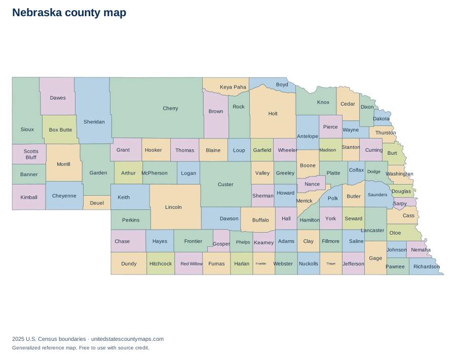
Nebraska county geography overview
Nebraska has 93 counties, which places it 11th among the 50 state and District of Columbia maps in this atlas when ordered by number of county-level units. Their combined 76,815.5 square miles of land place the state 15th by mapped land area.
The average county-level area is 826 square miles, while the median is 575.2 square miles. The median is often the better description of a typical unit because one or two very large areas can pull the average upward. The five largest units together account for about 21% of the state’s mapped land area.
Largest and smallest Nebraska counties
Cherry County is the largest county-level unit by land area at 5,960.1 square miles. It represents about 8% of all mapped land in Nebraska. At the other end of the range, Sarpy County has 238 square miles of land.
Largest by land area
- Cherry County5,960.1 sq mi
- Custer County2,575.5 sq mi
- Lincoln County2,564.2 sq mi
- Sheridan County2,440.2 sq mi
- Holt County2,411.9 sq mi
Smallest by land area
- Sarpy County238 sq mi
- Dakota County264.4 sq mi
- Douglas County326.5 sq mi
- Johnson County376.1 sq mi
- Washington County389.9 sq mi
Rankings use land area rather than total area. This avoids making coastal or lake counties appear larger solely because their boundaries include extensive water.
Alphabetical list of Nebraska counties
The table is alphabetical, so it works as a name and FIPS-code reference rather than an area ranking. Every identifier begins with the Nebraska state FIPS prefix 31. Land and water figures are rounded to one decimal place.
93 county-level areas
Download county data / numbered map key (CSV)| No. | Name | FIPS code | Land area | Water area |
|---|---|---|---|---|
| 1 | Adams County | 31001 | 563.3 sq mi | 1 sq mi |
| 2 | Antelope County | 31003 | 857.2 sq mi | 1.4 sq mi |
| 3 | Arthur County | 31005 | 715.2 sq mi | 3 sq mi |
| 4 | Banner County | 31007 | 746 sq mi | 0.2 sq mi |
| 5 | Blaine County | 31009 | 710.7 sq mi | 3.6 sq mi |
| 6 | Boone County | 31011 | 686.5 sq mi | 0.7 sq mi |
| 7 | Box Butte County | 31013 | 1,075.2 sq mi | 2.7 sq mi |
| 8 | Boyd County | 31015 | 539.4 sq mi | 5.2 sq mi |
| 9 | Brown County | 31017 | 1,221.4 sq mi | 3.7 sq mi |
| 10 | Buffalo County | 31019 | 968.2 sq mi | 7.2 sq mi |
| 11 | Burt County | 31021 | 491.6 sq mi | 5.5 sq mi |
| 12 | Butler County | 31023 | 584.8 sq mi | 6 sq mi |
| 13 | Cass County | 31025 | 556.9 sq mi | 9 sq mi |
| 14 | Cedar County | 31027 | 740.2 sq mi | 5.7 sq mi |
| 15 | Chase County | 31029 | 894.4 sq mi | 3.1 sq mi |
| 16 | Cherry County | 31031 | 5,960.1 sq mi | 49.5 sq mi |
| 17 | Cheyenne County | 31033 | 1,196 sq mi | 0.1 sq mi |
| 18 | Clay County | 31035 | 572.3 sq mi | 1.2 sq mi |
| 19 | Colfax County | 31037 | 411.5 sq mi | 5.1 sq mi |
| 20 | Cuming County | 31039 | 570.5 sq mi | 4.2 sq mi |
| 21 | Custer County | 31041 | 2,575.5 sq mi | 0.5 sq mi |
| 22 | Dakota County | 31043 | 264.4 sq mi | 3 sq mi |
| 23 | Dawes County | 31045 | 1,396.4 sq mi | 4.5 sq mi |
| 24 | Dawson County | 31047 | 1,013.8 sq mi | 5.6 sq mi |
| 25 | Deuel County | 31049 | 439.8 sq mi | 0.9 sq mi |
| 26 | Dixon County | 31051 | 475.6 sq mi | 7.1 sq mi |
| 27 | Dodge County | 31053 | 528.8 sq mi | 14.2 sq mi |
| 28 | Douglas County | 31055 | 326.5 sq mi | 12.8 sq mi |
| 29 | Dundy County | 31057 | 919.7 sq mi | 1.2 sq mi |
| 30 | Fillmore County | 31059 | 575.4 sq mi | 1.2 sq mi |
| 31 | Franklin County | 31061 | 575.8 sq mi | 0.2 sq mi |
| 32 | Frontier County | 31063 | 974.7 sq mi | 5.4 sq mi |
| 33 | Furnas County | 31065 | 719.2 sq mi | 1.4 sq mi |
| 34 | Gage County | 31067 | 851.5 sq mi | 8.5 sq mi |
| 35 | Garden County | 31069 | 1,704.8 sq mi | 26 sq mi |
| 36 | Garfield County | 31071 | 569.4 sq mi | 2 sq mi |
| 37 | Gosper County | 31073 | 458.2 sq mi | 4.5 sq mi |
| 38 | Grant County | 31075 | 776.7 sq mi | 6.7 sq mi |
| 39 | Greeley County | 31077 | 569.8 sq mi | 0.8 sq mi |
| 40 | Hall County | 31079 | 546.5 sq mi | 5.6 sq mi |
| 41 | Hamilton County | 31081 | 542 sq mi | 2.7 sq mi |
| 42 | Harlan County | 31083 | 553.5 sq mi | 20.6 sq mi |
| 43 | Hayes County | 31085 | 713.1 sq mi | 0.2 sq mi |
| 44 | Hitchcock County | 31087 | 710 sq mi | 8.5 sq mi |
| 45 | Holt County | 31089 | 2,411.9 sq mi | 5.6 sq mi |
| 46 | Hooker County | 31091 | 721 sq mi | 0.5 sq mi |
| 47 | Howard County | 31093 | 569.3 sq mi | 6.3 sq mi |
| 48 | Jefferson County | 31095 | 570.2 sq mi | 5.5 sq mi |
| 49 | Johnson County | 31097 | 376.1 sq mi | 0.6 sq mi |
| 50 | Kearney County | 31099 | 516.2 sq mi | 0.2 sq mi |
| 51 | Keith County | 31101 | 1,062.1 sq mi | 47.8 sq mi |
| 52 | Keya Paha County | 31103 | 772.9 sq mi | 1 sq mi |
| 53 | Kimball County | 31105 | 951.9 sq mi | 0.6 sq mi |
| 54 | Knox County | 31107 | 1,108.2 sq mi | 31.5 sq mi |
| 55 | Lancaster County | 31109 | 837.6 sq mi | 8.8 sq mi |
| 56 | Lincoln County | 31111 | 2,564.2 sq mi | 11 sq mi |
| 57 | Logan County | 31113 | 570.7 sq mi | 0.5 sq mi |
| 58 | Loup County | 31115 | 563.3 sq mi | 7.7 sq mi |
| 59 | Madison County | 31119 | 572.6 sq mi | 2.8 sq mi |
| 60 | McPherson County | 31117 | 859.3 sq mi | 1 sq mi |
| 61 | Merrick County | 31121 | 487.8 sq mi | 9 sq mi |
| 62 | Morrill County | 31123 | 1,423.7 sq mi | 6.4 sq mi |
| 63 | Nance County | 31125 | 441.6 sq mi | 6.6 sq mi |
| 64 | Nemaha County | 31127 | 407.3 sq mi | 2.3 sq mi |
| 65 | Nuckolls County | 31129 | 575.2 sq mi | 0.7 sq mi |
| 66 | Otoe County | 31131 | 615.6 sq mi | 3.4 sq mi |
| 67 | Pawnee County | 31133 | 431.1 sq mi | 1.9 sq mi |
| 68 | Perkins County | 31135 | 883.3 sq mi | 1.1 sq mi |
| 69 | Phelps County | 31137 | 539.8 sq mi | 0.7 sq mi |
| 70 | Pierce County | 31139 | 573.2 sq mi | 1.3 sq mi |
| 71 | Platte County | 31141 | 675.1 sq mi | 9.5 sq mi |
| 72 | Polk County | 31143 | 438.8 sq mi | 1.8 sq mi |
| 73 | Red Willow County | 31145 | 717.2 sq mi | 0.8 sq mi |
| 74 | Richardson County | 31147 | 551.8 sq mi | 2.7 sq mi |
| 75 | Rock County | 31149 | 1,008.3 sq mi | 3.4 sq mi |
| 76 | Saline County | 31151 | 574.1 sq mi | 2.2 sq mi |
| 77 | Sarpy County | 31153 | 238 sq mi | 9.5 sq mi |
| 78 | Saunders County | 31155 | 748.7 sq mi | 11.1 sq mi |
| 79 | Scotts Bluff County | 31157 | 739.6 sq mi | 5.9 sq mi |
| 80 | Seward County | 31159 | 571.4 sq mi | 4.5 sq mi |
| 81 | Sheridan County | 31161 | 2,440.2 sq mi | 29.6 sq mi |
| 82 | Sherman County | 31163 | 565.9 sq mi | 5.8 sq mi |
| 83 | Sioux County | 31165 | 2,066.7 sq mi | 0.6 sq mi |
| 84 | Stanton County | 31167 | 427.6 sq mi | 3.4 sq mi |
| 85 | Thayer County | 31169 | 573.8 sq mi | 1.2 sq mi |
| 86 | Thomas County | 31171 | 712.6 sq mi | 0.8 sq mi |
| 87 | Thurston County | 31173 | 393.6 sq mi | 2.5 sq mi |
| 88 | Valley County | 31175 | 568.1 sq mi | 2.4 sq mi |
| 89 | Washington County | 31177 | 389.9 sq mi | 3.3 sq mi |
| 90 | Wayne County | 31179 | 442.9 sq mi | 0.4 sq mi |
| 91 | Webster County | 31181 | 574.9 sq mi | 0.1 sq mi |
| 92 | Wheeler County | 31183 | 575.2 sq mi | 0.4 sq mi |
| 93 | York County | 31185 | 572.5 sq mi | 3.3 sq mi |
How to read and use this map
County lines are administrative boundaries, not postal routes. A mailing address can use a city name associated with a neighboring area, and ZIP codes can cross county lines. When you need to identify a county for an address, confirm it with an official geocoder or local government source.
For classroom or planning use, download a PDF from the controls above. Labelled exports use numbered callouts for crowded areas; numbered quiz maps match the alphabetical county list. SVG files keep the boundary lines sharp at larger paper sizes.
Frequently asked questions
How many counties are in Nebraska?
Nebraska has 93 counties in the U.S. Census Bureau’s 2025 cartographic boundary file.
Can I print this Nebraska county map?
Yes. Choose Download / print and select PDF for a landscape Letter page, PNG for an image, or SVG for editable vector artwork. Because the map is SVG, its boundary lines stay sharp when scaled.
What is the largest county in Nebraska?
Cherry County is the largest by land area in this dataset at 5,960.1 square miles. This is an area ranking, not a population ranking.
What is the smallest county in Nebraska?
Sarpy County is the smallest by land area in this dataset at 238 square miles.
Are these legal survey boundaries?
No. This is a generalized reference map. Property, parcel, election, and legal boundary questions should be checked with the relevant state or local agency.
Map source
U.S. Census Bureau, 2025 Cartographic Boundary File, Counties, 1:5,000,000. Land and water area fields are supplied in the same file and converted from square meters to square miles. Accessed September 27, 2026.