
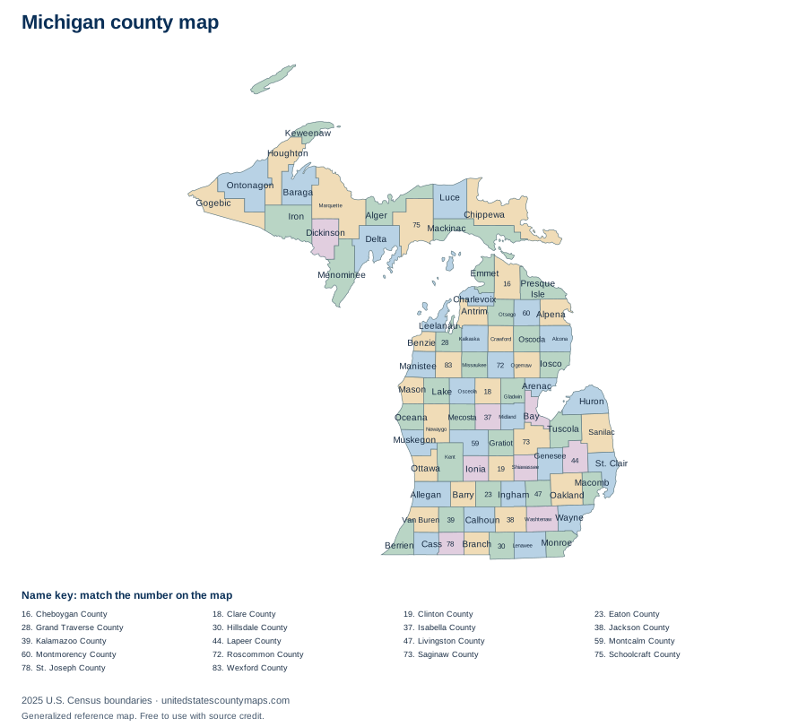
Michigan county geography overview
Michigan has 83 counties, which places it 15th among the 50 state and District of Columbia maps in this atlas when ordered by number of county-level units. Their combined 56,612.4 square miles of land place the state 22nd by mapped land area.
The average county-level area is 682 square miles, while the median is 567.8 square miles. The median is often the better description of a typical unit because one or two very large areas can pull the average upward. The five largest units together account for about 12% of the state’s mapped land area.
Largest and smallest Michigan counties
Marquette County is the largest county-level unit by land area at 1,809.1 square miles. It represents about 3% of all mapped land in Michigan. At the other end of the range, Benzie County has 319.7 square miles of land.
Largest by land area
- Marquette County1,809.1 sq mi
- Chippewa County1,558.5 sq mi
- Ontonagon County1,311 sq mi
- Schoolcraft County1,171.9 sq mi
- Delta County1,171.1 sq mi
Smallest by land area
- Benzie County319.7 sq mi
- Leelanau County347.2 sq mi
- Arenac County363.2 sq mi
- Charlevoix County416.3 sq mi
- Bay County442.4 sq mi
Rankings use land area rather than total area. This avoids making coastal or lake counties appear larger solely because their boundaries include extensive water.
Alphabetical list of Michigan counties
The table is alphabetical, so it works as a name and FIPS-code reference rather than an area ranking. Every identifier begins with the Michigan state FIPS prefix 26. Land and water figures are rounded to one decimal place.
83 county-level areas
Download county data / numbered map key (CSV)| No. | Name | FIPS code | Land area | Water area |
|---|---|---|---|---|
| 1 | Alcona County | 26001 | 674.7 sq mi | 1,116 sq mi |
| 2 | Alger County | 26003 | 915 sq mi | 4,132.6 sq mi |
| 3 | Allegan County | 26005 | 825.4 sq mi | 1,007.9 sq mi |
| 4 | Alpena County | 26007 | 571.9 sq mi | 1,123 sq mi |
| 5 | Antrim County | 26009 | 475.7 sq mi | 126.1 sq mi |
| 6 | Arenac County | 26011 | 363.2 sq mi | 317.5 sq mi |
| 7 | Baraga County | 26013 | 898.4 sq mi | 170.5 sq mi |
| 8 | Barry County | 26015 | 553.1 sq mi | 23.9 sq mi |
| 9 | Bay County | 26017 | 442.4 sq mi | 188.3 sq mi |
| 10 | Benzie County | 26019 | 319.7 sq mi | 539.9 sq mi |
| 11 | Berrien County | 26021 | 567.8 sq mi | 1,013.6 sq mi |
| 12 | Branch County | 26023 | 506.4 sq mi | 13.3 sq mi |
| 13 | Calhoun County | 26025 | 706.3 sq mi | 12.1 sq mi |
| 14 | Cass County | 26027 | 490.1 sq mi | 18.2 sq mi |
| 15 | Charlevoix County | 26029 | 416.3 sq mi | 974.1 sq mi |
| 16 | Cheboygan County | 26031 | 715.3 sq mi | 170.1 sq mi |
| 17 | Chippewa County | 26033 | 1,558.5 sq mi | 1,140 sq mi |
| 18 | Clare County | 26035 | 564.4 sq mi | 11 sq mi |
| 19 | Clinton County | 26037 | 567.3 sq mi | 7.2 sq mi |
| 20 | Crawford County | 26039 | 556.4 sq mi | 6.9 sq mi |
| 21 | Delta County | 26041 | 1,171.1 sq mi | 820.2 sq mi |
| 22 | Dickinson County | 26043 | 761 sq mi | 15.6 sq mi |
| 23 | Eaton County | 26045 | 575.2 sq mi | 4.2 sq mi |
| 24 | Emmet County | 26047 | 467.5 sq mi | 414.5 sq mi |
| 25 | Genesee County | 26049 | 636.9 sq mi | 12.6 sq mi |
| 26 | Gladwin County | 26051 | 501.8 sq mi | 14.2 sq mi |
| 27 | Gogebic County | 26053 | 1,102.1 sq mi | 374.6 sq mi |
| 28 | Grand Traverse County | 26055 | 464.3 sq mi | 137 sq mi |
| 29 | Gratiot County | 26057 | 568.4 sq mi | 3.2 sq mi |
| 30 | Hillsdale County | 26059 | 598.2 sq mi | 8.8 sq mi |
| 31 | Houghton County | 26061 | 1,009.1 sq mi | 492.4 sq mi |
| 32 | Huron County | 26063 | 835.9 sq mi | 1,300.9 sq mi |
| 33 | Ingham County | 26065 | 556.1 sq mi | 4.6 sq mi |
| 34 | Ionia County | 26067 | 571.3 sq mi | 8.7 sq mi |
| 35 | Iosco County | 26069 | 549.5 sq mi | 1,340.6 sq mi |
| 36 | Iron County | 26071 | 1,166.1 sq mi | 45.1 sq mi |
| 37 | Isabella County | 26073 | 572.7 sq mi | 5 sq mi |
| 38 | Jackson County | 26075 | 701.9 sq mi | 21.6 sq mi |
| 39 | Kalamazoo County | 26077 | 562 sq mi | 18.3 sq mi |
| 40 | Kalkaska County | 26079 | 559.7 sq mi | 10.8 sq mi |
| 41 | Kent County | 26081 | 849.5 sq mi | 22.4 sq mi |
| 42 | Keweenaw County | 26083 | 540.1 sq mi | 5,426.2 sq mi |
| 43 | Lake County | 26085 | 567.6 sq mi | 6.7 sq mi |
| 44 | Lapeer County | 26087 | 647.5 sq mi | 15.4 sq mi |
| 45 | Leelanau County | 26089 | 347.2 sq mi | 2,185 sq mi |
| 46 | Lenawee County | 26091 | 749.7 sq mi | 11.7 sq mi |
| 47 | Livingston County | 26093 | 565.3 sq mi | 20.1 sq mi |
| 48 | Luce County | 26095 | 899.1 sq mi | 1,013.4 sq mi |
| 49 | Mackinac County | 26097 | 1,021.9 sq mi | 1,078.7 sq mi |
| 50 | Macomb County | 26099 | 479.4 sq mi | 91.6 sq mi |
| 51 | Manistee County | 26101 | 542.3 sq mi | 738.4 sq mi |
| 52 | Marquette County | 26103 | 1,809.1 sq mi | 1,615.9 sq mi |
| 53 | Mason County | 26105 | 495 sq mi | 747.3 sq mi |
| 54 | Mecosta County | 26107 | 555.2 sq mi | 16.1 sq mi |
| 55 | Menominee County | 26109 | 1,044 sq mi | 294.1 sq mi |
| 56 | Midland County | 26111 | 518.4 sq mi | 9.6 sq mi |
| 57 | Missaukee County | 26113 | 564.8 sq mi | 9.1 sq mi |
| 58 | Monroe County | 26115 | 549.4 sq mi | 130.6 sq mi |
| 59 | Montcalm County | 26117 | 705.3 sq mi | 15.4 sq mi |
| 60 | Montmorency County | 26119 | 546.7 sq mi | 16 sq mi |
| 61 | Muskegon County | 26121 | 503.9 sq mi | 956.1 sq mi |
| 62 | Newaygo County | 26123 | 838.9 sq mi | 22.8 sq mi |
| 63 | Oakland County | 26125 | 867.4 sq mi | 39.8 sq mi |
| 64 | Oceana County | 26127 | 538.1 sq mi | 767.8 sq mi |
| 65 | Ogemaw County | 26129 | 563.5 sq mi | 11.4 sq mi |
| 66 | Ontonagon County | 26131 | 1,311 sq mi | 2,429.5 sq mi |
| 67 | Osceola County | 26133 | 566.3 sq mi | 6.7 sq mi |
| 68 | Oscoda County | 26135 | 565.7 sq mi | 5.8 sq mi |
| 69 | Otsego County | 26137 | 515 sq mi | 11.2 sq mi |
| 70 | Ottawa County | 26139 | 563.5 sq mi | 1,067.9 sq mi |
| 71 | Presque Isle County | 26141 | 658.7 sq mi | 1,914 sq mi |
| 72 | Roscommon County | 26143 | 519.9 sq mi | 60.1 sq mi |
| 73 | Saginaw County | 26145 | 800.8 sq mi | 15.2 sq mi |
| 74 | Sanilac County | 26151 | 962.6 sq mi | 627.4 sq mi |
| 75 | Schoolcraft County | 26153 | 1,171.9 sq mi | 712.1 sq mi |
| 76 | Shiawassee County | 26155 | 531.1 sq mi | 9.8 sq mi |
| 77 | St. Clair County | 26147 | 721.5 sq mi | 115 sq mi |
| 78 | St. Joseph County | 26149 | 500.6 sq mi | 20.4 sq mi |
| 79 | Tuscola County | 26157 | 804.9 sq mi | 109 sq mi |
| 80 | Van Buren County | 26159 | 607.8 sq mi | 482.1 sq mi |
| 81 | Washtenaw County | 26161 | 706 sq mi | 16.4 sq mi |
| 82 | Wayne County | 26163 | 611.8 sq mi | 60.5 sq mi |
| 83 | Wexford County | 26165 | 564.9 sq mi | 10.5 sq mi |
How to read and use this map
County lines are administrative boundaries, not postal routes. A mailing address can use a city name associated with a neighboring area, and ZIP codes can cross county lines. When you need to identify a county for an address, confirm it with an official geocoder or local government source.
For classroom or planning use, download a PDF from the controls above. Labelled exports use numbered callouts for crowded areas; numbered quiz maps match the alphabetical county list. SVG files keep the boundary lines sharp at larger paper sizes.
Interpreting the water figure: About 41% of the summed mapped area in this state is water. County water area can include coastal waters, bays, lakes, or rivers assigned by the Census boundary file; it is shown separately from land and should not be used to estimate developable land.
Frequently asked questions
How many counties are in Michigan?
Michigan has 83 counties in the U.S. Census Bureau’s 2025 cartographic boundary file.
Can I print this Michigan county map?
Yes. Choose Download / print and select PDF for a landscape Letter page, PNG for an image, or SVG for editable vector artwork. Because the map is SVG, its boundary lines stay sharp when scaled.
What is the largest county in Michigan?
Marquette County is the largest by land area in this dataset at 1,809.1 square miles. This is an area ranking, not a population ranking.
What is the smallest county in Michigan?
Benzie County is the smallest by land area in this dataset at 319.7 square miles.
Are these legal survey boundaries?
No. This is a generalized reference map. Property, parcel, election, and legal boundary questions should be checked with the relevant state or local agency.
Map source
U.S. Census Bureau, 2025 Cartographic Boundary File, Counties, 1:5,000,000. Land and water area fields are supplied in the same file and converted from square meters to square miles. Accessed September 27, 2026.