
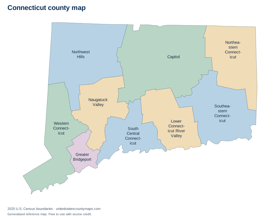
Connecticut county geography overview
Connecticut has 9 planning regions, which places it 47th among the 50 state and District of Columbia maps in this atlas when ordered by number of county-level units. Their combined 4,842.5 square miles of land place the state 48th by mapped land area.
The average county-level area is 538 square miles, while the median is 532.1 square miles. The median is often the better description of a typical unit because one or two very large areas can pull the average upward. The five largest units together account for about 72% of the state’s mapped land area.
Largest and smallest Connecticut planning regions
Capitol Planning Region is the largest county-level unit by land area at 1,027.4 square miles. It represents about 21% of all mapped land in Connecticut. At the other end of the range, Greater Bridgeport Planning Region has 140.2 square miles of land.
Largest by land area
- Capitol Planning Region1,027.4 sq mi
- Northwest Hills Planning Region786.6 sq mi
- Southeastern Connecticut Planning Region598.1 sq mi
- Northeastern Connecticut Planning Region553.9 sq mi
- Western Connecticut Planning Region532.1 sq mi
Smallest by land area
- Greater Bridgeport Planning Region140.2 sq mi
- South Central Connecticut Planning Region367.3 sq mi
- Naugatuck Valley Planning Region412.8 sq mi
- Lower Connecticut River Valley Planning Region424.1 sq mi
- Western Connecticut Planning Region532.1 sq mi
Rankings use land area rather than total area. This avoids making coastal or lake counties appear larger solely because their boundaries include extensive water.
Alphabetical list of Connecticut planning regions
The table is alphabetical, so it works as a name and FIPS-code reference rather than an area ranking. Every identifier begins with the Connecticut state FIPS prefix 09. Land and water figures are rounded to one decimal place.
9 county-level areas
Download county data / numbered map key (CSV)| No. | Name | FIPS code | Land area | Water area |
|---|---|---|---|---|
| 1 | Capitol Planning Region | 09110 | 1,027.4 sq mi | 18.8 sq mi |
| 2 | Greater Bridgeport Planning Region | 09120 | 140.2 sq mi | 98 sq mi |
| 3 | Lower Connecticut River Valley Planning Region | 09130 | 424.1 sq mi | 93.1 sq mi |
| 4 | Naugatuck Valley Planning Region | 09140 | 412.8 sq mi | 8.8 sq mi |
| 5 | Northeastern Connecticut Planning Region | 09150 | 553.9 sq mi | 9.3 sq mi |
| 6 | Northwest Hills Planning Region | 09160 | 786.6 sq mi | 21.5 sq mi |
| 7 | South Central Connecticut Planning Region | 09170 | 367.3 sq mi | 252.3 sq mi |
| 8 | Southeastern Connecticut Planning Region | 09180 | 598.1 sq mi | 83.6 sq mi |
| 9 | Western Connecticut Planning Region | 09190 | 532.1 sq mi | 115.9 sq mi |
How to read and use this map
County lines are administrative boundaries, not postal routes. A mailing address can use a city name associated with a neighboring area, and ZIP codes can cross county lines. When you need to identify a county for an address, confirm it with an official geocoder or local government source.
For classroom or planning use, download a PDF from the controls above. Labelled exports use numbered callouts for crowded areas; numbered quiz maps match the alphabetical county list. SVG files keep the boundary lines sharp at larger paper sizes.
Frequently asked questions
How many planning regions are in Connecticut?
Connecticut has 9 planning regions in the U.S. Census Bureau’s 2025 cartographic boundary file.
Can I print this Connecticut county map?
Yes. Choose Download / print and select PDF for a landscape Letter page, PNG for an image, or SVG for editable vector artwork. Because the map is SVG, its boundary lines stay sharp when scaled.
What is the largest county-level area in Connecticut?
Capitol Planning Region is the largest by land area in this dataset at 1,027.4 square miles. This is an area ranking, not a population ranking.
What is the smallest county-level area in Connecticut?
Greater Bridgeport Planning Region is the smallest by land area in this dataset at 140.2 square miles.
Are these legal survey boundaries?
No. This is a generalized reference map. Property, parcel, election, and legal boundary questions should be checked with the relevant state or local agency.
Map source
U.S. Census Bureau, 2025 Cartographic Boundary File, Counties, 1:5,000,000. Land and water area fields are supplied in the same file and converted from square meters to square miles. Accessed September 27, 2026.